HOW PUBLIC TRANSPORT WORKS IN ROME 🚇
The essential guide to using Rome’s metro, buses and tickets without wasting time, money or energy.
Sara in Italy
Rome, Italy

Rome is one of the most walkable cities in the world, but you should not try to walk absolutely everywhere.
The historic center is best experienced on foot, but Rome is large, hot in summer, full of cobblestones, and spread across many different neighborhoods. If you understand how public transport works, you can save time, energy, and a lot of unnecessary frustration.
Rome’s public transport network includes:
🚇 Metro
🚌 Buses
🚋 Trams
🚎 Trolleybuses
🚆 Urban railways
🌙 Night buses
The main operator is ATAC, Rome’s public transport company. The official ATAC website provides downloadable maps for the city center, the urban metro-rail network, night lines, tram lines, Ostia, suburban lines and the full Rome network.
The most important thing to understand is this:
The metro is easier, but limited. Buses cover more areas, but they are slower and less predictable.
So the smartest way to move around Rome is to use the metro for longer distances, buses only when they genuinely help, and your feet for the historic center.
🚇 Rome Metro: The Simple Explanation
Rome currently has three main metro lines:
🟠 Line A
🔵 Line B / B1
🟢 Line C
The official urban metro-rail map shows Metro A, Metro B/B1, Metro C, and urban rail connections. As of the updated ATAC metro-rail map, Metro C runs from Monte Compatri/Pantano to Colosseo, while Metro A runs Anagnina–Battistini and Metro B/B1 runs Laurentina–Rebibbia / Laurentina–Jonio.
The metro is usually the easiest system for first-time visitors because you only need to understand the line color and the final direction.
For example, you do not usually say “take Metro A north.” You say:
Take Metro A toward Battistini
or
Take Metro A toward Anagnina
The final station tells you the direction.
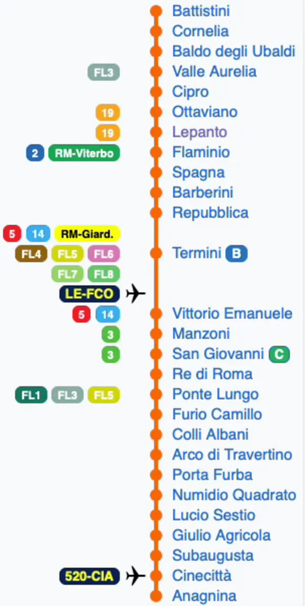
🟠 Metro Line A: Battistini ↔ Anagnina
Metro A is one of the most useful lines for tourists because it connects several major areas: the Vatican side, Piazza del Popolo, Spanish Steps, Trevi area, Termini, San Giovanni, and the southeast of Rome.
Direction 1: Toward Battistini
Use this direction if you are going toward the Vatican / Prati / northwest Rome.
Direction 2: Toward Anagnina
Use this direction if you are going toward Termini, San Giovanni, Cinecittà, or southeast Rome.
Main tourist-useful stations on Line A
Ottaviano – San Pietro – Musei Vaticani
Best for: Vatican Museums, Sistine Chapel, St. Peter’s Basilica, Prati.
Lepanto
Best for: Prati, quieter access to the Vatican area, Castel Sant’Angelo by walking.
Flaminio – Piazza del Popolo
Best for: Piazza del Popolo, Villa Borghese, Pincio Terrace, Via del Corso.
Spagna
Best for: Spanish Steps, luxury shopping, Via Condotti, Villa Borghese access.
Barberini – Fontana di Trevi
Best for: Trevi Fountain area, Via Veneto, Barberini Palace.
Repubblica – Teatro dell’Opera
Best for: Piazza della Repubblica, Opera House, Termini area.
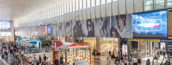
Termini
Best for: main train station, airport trains, Metro A/B interchange, buses.
Vittorio Emanuele
Best for: Esquilino, local food markets, Santa Maria Maggiore area.
Manzoni – Museo della Liberazione
Best for: San Giovanni / Lateran area.
San Giovanni
Best for: Basilica di San Giovanni in Laterano and interchange with Metro C.
Cinecittà
Best for: Cinecittà Studios.
Line A operating hours
Roma Mobilità lists Line A as running from 5:30 AM from both Anagnina and Battistini, with last departures at 11:30 PM Sunday to Thursday and 1:30 AM on Friday and Saturday.
Sara’s tip:
If you are staying near Metro A, Rome becomes much easier. For a first trip, areas near Ottaviano, Lepanto, Flaminio, Spagna, Barberini, Repubblica, Termini, or San Giovanni are strategically useful.
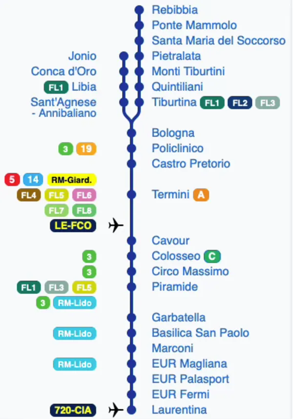
🔵 Metro Line B / B1: Laurentina ↔ Rebibbia / Jonio
Metro B is very important because it connects Termini with Ancient Rome, the Colosseum, Circo Massimo, Piramide, Ostiense, and the EUR area.
The only confusing part is the split:
B = Laurentina ↔ Rebibbia
B1 = Laurentina ↔ Jonio
Both share the same route for part of the journey, then split after Bologna.
Direction 1: Toward Laurentina
Use this direction if you are going south toward Colosseum, Circo Massimo, Piramide, Basilica San Paolo, EUR.
Direction 2: Toward Rebibbia
Use this direction if you are going northeast toward Tiburtina, Ponte Mammolo, Rebibbia.
Direction 3: Toward Jonio
Use this direction if you are going toward the B1 branch: Sant’Agnese/Annibaliano, Libia, Conca d’Oro, Jonio.
Main tourist-useful stations on Line B / B1
Termini
Best for: main station, Metro A interchange, buses, trains.
Cavour
Best for: Monti neighborhood, restaurants, boutiques, walk to Colosseum.
Colosseo
Best for: Colosseum, Roman Forum, Palatine Hill, Via dei Fori Imperiali. Also connects with Metro C at Colosseo / Fori Imperiali on the updated network.
Circo Massimo
Best for: Circus Maximus, Aventine Hill, Orange Garden, Baths of Caracalla.
Piramide
Best for: Testaccio, Ostiense, Protestant Cemetery, Eataly area, Roma Ostiense station.
Basilica San Paolo
Best for: Basilica of St. Paul Outside the Walls.
EUR Magliana / EUR Palasport / EUR Fermi
Best for: EUR district, Palazzo della Civiltà Italiana, modern Rome.
Tiburtina
Best for: Roma Tiburtina train station, high-speed trains, regional connections.
Bologna
Best for: university area, local neighborhood, branch point for B/B1.
Line B / B1 operating hours
Roma Mobilità lists Line B as starting at 5:30 AM, with last departures around 11:27–11:30 PM Sunday to Thursdayand around 1:27–1:30 AM on Friday and Saturday, depending on direction. Line B1 starts at 5:33 AM, with last departures around 11:27–11:30 PM Sunday to Thursday and around 1:27–1:30 AM on Friday and Saturday.
Sara’s tip:
If you are going to the Colosseum, Metro B is your easiest option. But if you are staying inside the historic center, walking may still be more beautiful than taking a bus or metro for very short distances.
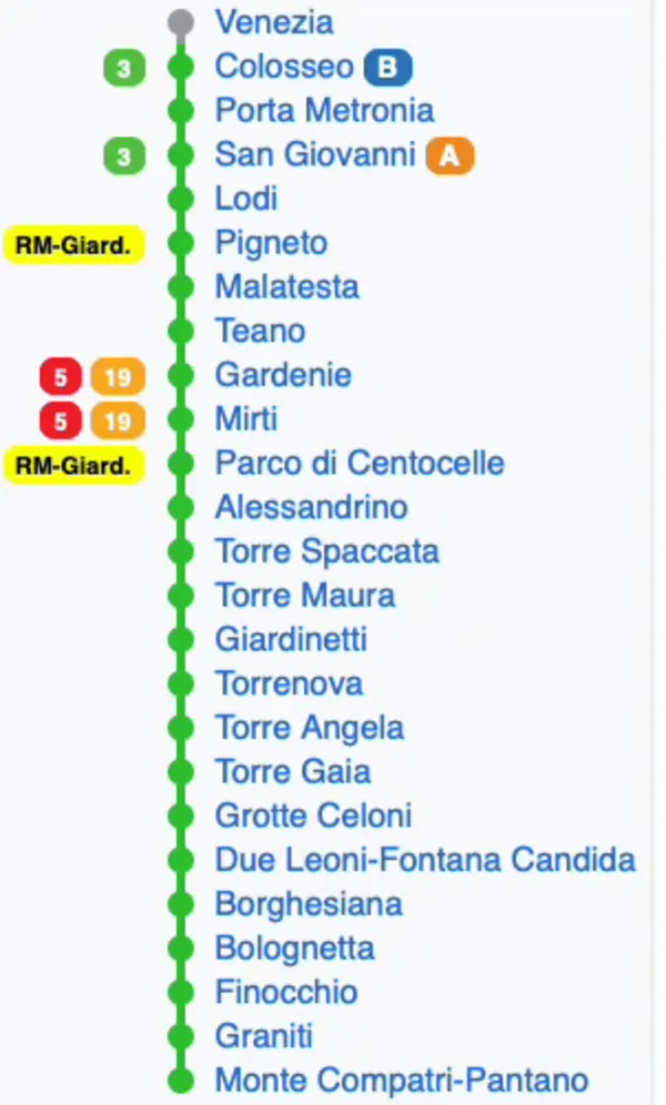
🟢 Metro Line C: Monte Compatri/Pantano ↔ Colosseo
Metro C is the newest and most modern line. It is especially useful if you are staying in the eastern part of Rome or need to connect to San Giovanni and the Colosseum area.
As of the updated official metro-rail map, Metro C runs from Monte Compatri/Pantano to Colosseo.
Roma Mobilità lists Line C as operating from 5:30 AM, with last departures at 11:30 PM Sunday to Thursday and 1:30 AM on Friday and Saturday.
Main tourist-useful stations on Line C
Colosseo / Fori Imperiali
Best for: Colosseum, Roman Forum, Imperial Forums, Monti, interchange with Metro B.
Porta Metronia
Best for: San Giovanni / Celio area and access to a less touristy side of central Rome.
San Giovanni
Best for: Basilica di San Giovanni in Laterano, shopping streets, interchange with Metro A.
Pigneto
Best for: nightlife, local food scene, creative neighborhood.
Malatesta / Teano / Gardenie / Mirti
Best for: residential eastern Rome.
Finocchio – Antica Città di Gabii
In May 2026, Roma Capitale announced that the name of the Metro C Finocchio stop was enriched with the reference to Antica Città di Gabii, connected to the archaeological area in Municipio VI.
Monte Compatri/Pantano
Best for: outer eastern terminus of Line C.
Sara’s tip:
Metro C is becoming more useful for visitors because it now reaches the Colosseum area. But for most first-time tourists staying in the historic center, Metro A and B are still the lines you will probably use most.
🗺️ Rome Metro Map in Words
Here is the simplest way to visualize the metro:
🟠 Line A
Battistini → Vatican area → Piazza del Popolo → Spanish Steps → Trevi area → Termini → San Giovanni → Cinecittà → Anagnina
Best for: Vatican, Spanish Steps, Trevi area, Termini, San Giovanni.
🔵 Line B
Laurentina → EUR → Basilica San Paolo → Piramide/Testaccio → Circo Massimo → Colosseo → Cavour/Monti → Termini → Bologna → Tiburtina → Rebibbia
Best for: Colosseum, Monti, Testaccio, Ostiense, EUR, Tiburtina.
🔵 Line B1
Laurentina → shared B route → Bologna → Sant’Agnese/Annibaliano → Libia → Conca d’Oro → Jonio
Best for: residential northern Rome.
🟢 Line C
Monte Compatri/Pantano → eastern Rome → Pigneto → San Giovanni → Porta Metronia → Colosseo / Fori Imperiali
Best for: eastern Rome, Pigneto, San Giovanni, Colosseum.
🎟️ Tickets: What You Actually Need
Rome uses integrated tickets for metro, buses, trams and some urban rail services within the urban area.
The main tourist tickets listed by ATAC are:
BIT 100-minute ticket: €1.50
Valid for 100 minutes. Best if you only use transport occasionally.
ROMA 24H ticket: €8.50
Valid for 24 hours from first validation.
ROMA 48H ticket: €15.00
Valid for 48 hours from first validation.
ROMA 72H ticket: €22.00
Valid for 72 hours from first validation.
CIS weekly ticket: €29.00
Valid for 7 days, until midnight of the seventh day including the day of validation, for unlimited journeys within Rome.
Turismo Roma also confirmed that from July 2025 the 24h, 48h, 72h and CIS prices increased to these amounts, while the 100-minute BIT remained unchanged.
💳 Tap&Go: The Easiest Way to Pay
If you have a contactless card or a phone/watch with NFC payments, Tap&Go is usually the easiest option.
ATAC states that Tap&Go works with contactless credit, debit or prepaid cards, and also with digital cards on NFC-enabled devices such as smartphones, smartwatches and wearables. It can be used on buses, trams, trolleybuses, metro lines A, B/B1 and C, and selected urban railways.
The important rules are:
✅ Tap every time you change vehicle.
✅ Use the same card or device for the whole journey.
✅ Do not tap with your physical card once and then your phone later, even if they are linked to the same bank card.
✅ One card/device = one passenger. You cannot pay for multiple people traveling with you using the same contactless card.
✅ Wait for the green light.
ATAC also warns that it does not send SMS messages asking for Tap&Go confirmations or payments; messages claiming incomplete Tap&Go validation may be phishing attempts.
Sara’s tip:
For most tourists, Tap&Go is easier than buying paper tickets — but only if every traveler has their own card or device.
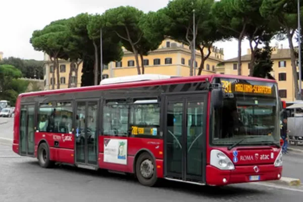
🚌 Rome Buses: Useful, But Not Always Easy
Buses are essential in Rome because the metro does not cover the whole historic center.
Many beautiful areas are not directly served by metro, including parts of:
📍 Campo de’ Fiori
📍 Piazza Navona
📍 Trastevere
📍 Gianicolo
📍 Jewish Quarter
📍 Aventine Hill
📍 Villa Borghese interior areas
📍 Some parts of the Vatican / Prati
📍 Appian Way access points
However, buses in Rome can be delayed by traffic, roadworks, demonstrations, diversions, summer heat and crowds. This is why I recommend buses only when they clearly save time or walking energy.
Roma Mobilità explains that Rome’s night network includes 47 lines from about 11:30 PM until dawn, including 15 daytime bus lines extended until 2:00 AM and 32 night “N” bus lines from 11:30 PM to 5:00 AM. Some night lines cover metro routes after metro service ends, including nMA, nMB, nMB1 and nMC.
🚌 Bus Lines Tourists Often Use
Important: bus routes in Rome can change because of roadworks, events and Metro C construction sites, especially around central areas such as Piazza Venezia. ATAC itself highlights service updates and changes connected to works and diversions, so always check the ATAC real-time planner before relying on a bus route.
That said, these are some types of buses travelers often find useful:
Termini ↔ Historic Center / Vatican area
Useful if you are moving between the main station, central Rome and the Vatican side.
Piazza Venezia / Largo Argentina area buses
Useful for reaching Campo de’ Fiori, Jewish Quarter, Pantheon area, and connections toward Trastevere.
Buses along the Tiber
Useful for moving between Vatican / Castel Sant’Angelo / Trastevere / Ostiense depending on route and direction.
Buses to Gianicolo
Useful if you want sunset views but do not want to climb too much.
Buses to Appian Way
Useful because the Appian Way is not directly in the historic center and usually requires a more intentional transport plan.
Sara’s tip:
Do not build your entire Rome itinerary around buses unless you are comfortable with delays. For tourists, buses are best used as support — not as the backbone of the whole trip.
📱 Best Apps and Tools to Use
Use official or real-time tools, not random screenshots from old blogs.
Best official tools
ATAC Maps
Use this for downloadable public transport maps: city center, full Rome network, metro-rail, night lines, tram lines, Ostia and suburban lines.
ATAC Real-Time / Journey Planner
Use this before taking buses or trams because diversions and delays are common. ATAC’s FAQ says routes and timetables can be found through its journey planner, and maps are downloadable from the Maps page.
Roma Mobilità
Use this for official mobility updates, metro operating hours, and city transport information.
Other useful tools
Google Maps can be helpful for general directions, but do not blindly trust bus times if traffic or diversions are happening.
Sara’s tip:
Before walking to a bus stop, check whether the bus is actually coming. In Rome, “the bus exists” and “the bus is useful right now” are not always the same thing.
🚆 Main Transport Hubs You Should Know
Termini
Rome’s main station. Interchange between Metro A and B. Also major hub for trains, buses, trams and airport connections. Roma Mobilità identifies Termini as the capital’s main station, with interchanges for Metro A and B, tram lines 5 and 14, trolleybus 90, ATAC and COTRAL buses and rail connections.
Tiburtina
Major train station and Metro B stop. Useful for high-speed trains, regional trains and buses. Roma Mobilità notes that Tiburtina is reachable from Fiumicino via FL1 and has Metro B interchange.
Ostiense / Piramide
Useful for Testaccio, Ostiense, Eataly, Roma Ostiense station and rail connections. Roma Mobilità lists Ostiense as a stop for FL1, FL3 and FL5, with interchange at Piramide Metro B and Roma-Lido/Metromare.
San Giovanni
Interchange between Metro A and Metro C. Useful for San Giovanni in Laterano and the eastern side of Rome.
Colosseo
Interchange between Metro B and Metro C on the updated network. Best for the Colosseum, Roman Forum, Palatine Hill and Imperial Forums.
🧭 How to Use Public Transport for the Main Tourist Areas
Colosseum / Roman Forum / Palatine Hill
Best metro: Metro B or C to Colosseo.
Best plan: arrive early, visit the archaeological area, then walk to Monti, Piazza Venezia, or Capitoline Hill.
Vatican Museums / St. Peter’s Basilica
Best metro: Metro A to Ottaviano – San Pietro – Musei Vaticani.
Alternative: Metro A to Lepanto, then walk through Prati.
Spanish Steps
Best metro: Metro A to Spagna.
Trevi Fountain
Best metro: Metro A to Barberini – Fontana di Trevi, then walk.
You can also walk from Spagna or the Pantheon area.
Pantheon / Piazza Navona / Campo de’ Fiori
No perfect metro stop directly in the middle.
Best plan: use metro to get near the area, then walk; or use buses depending on your exact starting point.
Trastevere
No metro in the heart of Trastevere.
Best plan: bus, tram, taxi, or walk depending on where you start. From the historic center, walking can be beautiful.
Testaccio / Ostiense
Best metro: Metro B to Piramide.
Villa Borghese
Best metro: Metro A to Flaminio or Spagna, then walk uphill or through the park.
Appian Way
Requires a more careful plan: bus, taxi, e-bike, or guided experience depending on the section you want to visit.
⚠️ Common Public Transport Mistakes in Rome
Mistake 1: Thinking the metro reaches everything
Rome’s metro is useful but limited. Many central places require walking or buses.
Mistake 2: Booking accommodation far from a metro stop
A cheaper hotel far from the metro can cost you time and energy every single day.
Mistake 3: Depending only on buses
Buses are useful, but traffic and diversions can make them unreliable.
Mistake 4: Not validating or tapping correctly
If you use Tap&Go, tap every time you change vehicle and always use the same card/device.
Mistake 5: Planning too many cross-city movements
Rome should be planned by areas, not by random attractions.
Mistake 6: Ignoring summer heat
A 20-minute walk in Rome in July can feel very different from a 20-minute walk in October.
Mistake 7: Assuming “near” means easy
Rome’s cobblestones, hills, crowds and traffic change everything.
✨ Sara’s Local Strategy
Use public transport like this:
🚇 Metro for long distances
Use it to move between major zones: Vatican, Termini, Colosseum, San Giovanni, Testaccio, EUR.
🚌 Bus only when it clearly saves you time
Especially for places not served by metro, but always check real-time arrivals.
🚶 Walk inside each neighborhood
Rome is most beautiful when explored slowly: Pantheon, Piazza Navona, Campo de’ Fiori, Trevi, Spanish Steps, Monti and Trastevere are often better on foot.
🚕 Taxi when public transport becomes inefficient
Sometimes paying for a taxi saves your whole afternoon, especially with luggage, late-night returns, extreme heat, or tired feet.
📌 The Smart Rome Rule
Do not ask:
“Can I get there by public transport?”
Ask:
“Is public transport the smartest option for this specific moment of the day?”
In Rome, the answer changes depending on:
⏰ time
☀️ heat
🚶 walking distance
🎒 luggage
🎟️ ticket time slots
🍝 restaurant reservations
🌙 night transport
🚧 roadworks
🚌 real-time bus arrivals
That is why planning Rome is not just about knowing the metro map. It is about knowing how to combine transport, neighborhoods, attractions, food stops and energy.
📌 Want Rome Already Planned for You?
This free guide explains how public transport works in Rome.
But the real challenge is knowing when to use it, when to walk, when to take a taxi, and how to structure your days without wasting time crossing the city again and again.
Inside my complete Rome guide, you will find curated itineraries, mapped routes, attraction planning, food stops, neighborhood logic and practical tips to help you move through Rome with confidence.
Instead of spending hours switching between Google Maps, TikTok, old blog posts and random recommendations, you can follow a clear, local-approved plan designed to make your Rome trip smoother, smarter and more beautiful.
Rome is not difficult when you understand how it works.
But it is much better when someone has already planned the hard parts for you.

Rome Without Regrets: The Ultimate Guide
Rome, Italy
Looking for things to do?
Go check out my guide for the best free things to do as well as itineraries and travel tips to make your trip unforgettable.