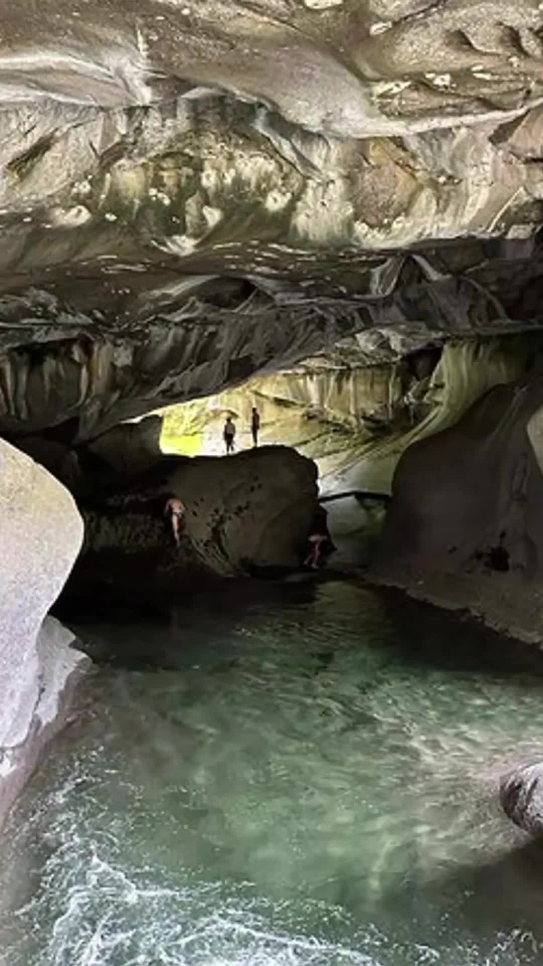
The Little Huson Cave system is a karst landscape formed by water eroding a deep limestone formation. You can explore natural limestone arches, dramatic cave entrances, sculpted rock platforms, and a large natural bridge over Atluck Creek, which is carved by the clear, emerald pools of Little Huson Lake. A short, winding trail leads to these formations, and while it's open year-round for day use, exploring some areas may require wading through water.
Getting There:
From Highway 19, turn into Woss.
Continue west on Nimpkish Mainline (gravel road).
Follow signs to Atluck Lake / Anutz Lake, then toward Little Huson Caves (some signage, but bring a backroads map or GPS).
The park is accessed via a small pullout with a sign and a trailhead.
Park and walk approximately 200 meters to the cave lookout.
Note: The roads are active logging roads—yield to industrial traffic, use headlights, and drive cautiously. No cell service past Woss.
Trail Type: Short interpretive loop
Distance: ~400 meters
Difficulty: Easy
Surface: Dirt and boardwalk
Time: ~15–30 minutes, depending on exploration
Family-Friendly: Yes – excellent educational stop for all ages
Camping: No camping permitted in the park itself. Nearby options include:
Atluck Lake Rec Site (~15 minutes away)
Anutz Lake Rec Site (~20 minutes away)
Dog Policy: Dogs are allowed but must be leashed
Trails have drop-offs—use caution with pets and children
Campfires: Not permitted in the park
Facilities: Small gravel parking lot. Picnic table and interpretive signage at the trailhead. No toilets, water, or garbage bins—pack in/pack out
The caves are set along Atluck Creek, which flows through the karst system. Water is not potable—do not drink
Dramatic limestone karst formations carved by water over millennia. View cave entrances, natural bridges, and sculpted pools. Small interpretive signs offer insight into cave ecology and geology. Photogenic rock features, overhangs, and shaded rainforest surroundings. Easy and peaceful stop on a Nimpkish Valley day trip
The best time to visit is late spring through early fall. Trails can be muddy in shoulder seasons. The dense forest provides shade; bring layers. Open year-round. Gravel access roads may be rough or muddy after rain. 2WD is passable in dry conditions, but 4WD is recommended in poor weather
Cultural & Historical Notes: Located within the traditional territory of the ’Namgis First Nation.
Limestone karst landscapes are ecologically sensitive and culturally significant
Visitors are asked to explore only established trails and not enter cave systems, which are fragile and potentially unsafe